(He, Guo et al., 2015)
By reviewing available data from different bibliographical sources, the authors arrive to the following results:
Grain size analysis
Bottom sediments in the middle and lower reaches of the river are fairly coarsely, with a median diameter of 50-300 µm. Sorting and mixing processes create a decreasing trend downriver. However, the presence of Three Gorges Dam —at the top of the middle reaches— has developed a coarsening downward trend in the sediment grain size in the last decade.
Sand is the main component of bottom sediments in the middle and lower Yangtze.
(He, Zheng et al., 2015)
30 bottom sediment samples from both the mainstream and major tributaries were analysed only for the fraction < 63 µm.
Major element chemistry
Sediments are quite immature geochemically, since they plot far from the quartz arenite area (see Fig. 1).
Sorting
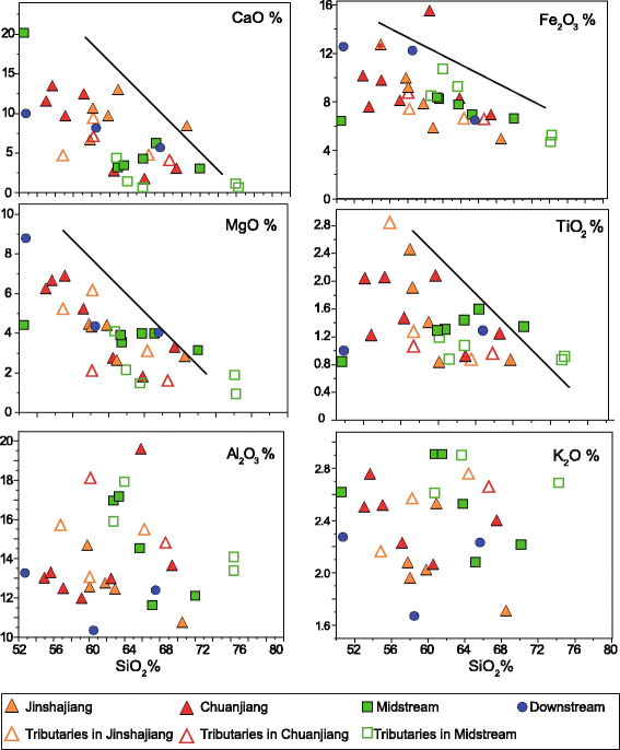
The lack of an association between Al2O3 or K2O concentrations (see Fig. 2) —which are mainly controlled by the presence of micas, feldspar and clay— and SiO2, suggest that there is no clear correlation between the amount of quartz in sand and feldspar.
The fact that both Fe2O3 and MgO —found in mafic, heavy minerals and iron oxides— show a negative correlation with SiO2 (see Fig. 2), accounts for the dilution trend by quartz. The total amount of quartz is a proxy for the composition of the source rock types, the sedimentary transport sorting and the chemical weathering. Thus, unless the sorting process can be effectively addressed, the concentrations of major elements would not make a reliable parameter for telling the sediment provenance.
Chemical weathering
K2O/Al2O3 is used as a proxy for chemical weathering since K is released during the breakdown of K-feldspars into the water. SiO2/Al2O3 is a proxy for grain size.
From Fig. 3a we can see how sandier sediments seem to be less weathered than muddier sediments. In Fig. 3b, CIA displays the same trend. In both cases there is no clear trend between the location of the sample along the river course with neither the degree of weathering nor the grain size. However, it is clear the forcing that grain size exerts on the alteration proxy.
Provenance
Using Nd isotopic composition, we can account for the sources of sediment. The differences in the values of εNd (see Fig. 4a) between upstream and downstream reaches account for the variation in parent source rock and the input of more sediment as the river flows downstream. He et al. (2013) and Iizuka et al. (2010) described the mid-lower basin as formed by Quaternary and lacustrine sediments, with intermediate felsic igneous rocks and metamorphic units, all being part of the older Yangtze Craton.
Trace element chemistry (Yangtze Craton)
Comparing the Yangtze River Basin trace element composition with that of the average upper continental crust (UCC), the finer-fraction of the sediments analysed here are more abundant in both heavy minerals and clay than the average UCC (see Fig. 5a). The major element composition also shows that Yangtze sediments held a higher density of heavy minerals than average UCC (see Fig. 5b).
RESULTS & DISCUSSION


(Yang et al., 2009)
23 floodplain sediment samples from both the mainstream and major tributaries were analysed for heavy minerals and detrital magnetite grains held in the very fine sand fraction 63-125 µm.
The majority of the samples from the mainstream and the tributaries are dominated by sand (see Fig. 6: plot Mz(µm) median grain size).
Heavy minerals
ZTR (zircon, tourmaline and rutile) values are the highest for the sample in the Xiangjiang tributary (due to the wide presence of granitoids), as a result of high Zr content (see Fig. 6: plot ZTR). Zr is a common accessory mineral of igneous rocks.
Detrital magnetite grains
Al2O3, Cr2O3 and MgO dominate the magnetite grains from the upper reaches of the Yangtze River (see Fig. 7), if compared with those from the middle-lower reaches.
Provenance
Since very fine sand is the major component of the sediments —which is generally rich in heavy minerals and even ultradense minerals— the fraction here analysed can indicate the general heavy minerals assemblages of the river sediments. The upper valley of the Yangtze is situated mainly in a tectonically active area. This favours the uplifting and exposure to weathering of the source rocks, thus causing a high concentration of heavy minerals in riverine sediments.
On the other hand, the middle-lower valley is more subjected to strong chemical weathering than tectonic movement. Here the soil layer is more developed and siliciclastic sedimentary rocks spread a fairly wide area. Thus, due to sediment recycling the concentration of heavy minerals is lower if compared to that of the sediments from upper reaches (see Fig. 6: plot Fe-Ti HM (heavy mineral group) and values for CJ-upper and CJ-lower; CJ: Changjiang mainstream sediments).
From Fig. 8, we can see that the majority of detrital magnetite grains found in the river sediments come from felsic plutonic and volcanic, and/or metamorphic parent rocks.


Fig. 1. (Source: He, Zheng et al., 2015)
Fig. 2. (Source: He, Zheng et al., 2015)
Fig. 3. (Source: He, Zheng et al., 2015)
Fig. 4. (Source: He, Zheng et al., 2015)
Fig. 5. a) Trace elements normalized to the UCC. b) Total major elements % normalized to UCC. (Source: He, Zheng et al., 2015)
Fig. 6. (Source: Yang et al., 2009)
Fig. 7. Average and standard deviation of concentration of magnetite grains in sediment samples from both the mainstream and tributaries of the Yangtze. The numbers of measured magnetite grains are shown under each tributary. (Source: Yang et al., 2009)
Fig. 8. (Source: Yang et al., 2009)

Topographic map of the Yangtze River Basin. Major tributaries and sampling points are shown. (Source: He, Zheng et al., 2015)
